Contents
Index
Filter Points
This is a tool to generalise and smooth a surface.
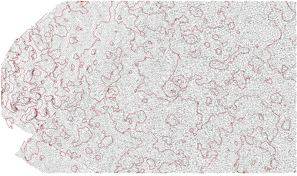
Where you have a large number of points which have been created from a mass sampling system such as LIDAR/Drone survey,
there will be overlapping points and irregularities in the readings.
If you simply contour the job you will get a contour map as below
where the contour lines are very irregular and contorted.
The "Filter Points" routine will generate another surface (mesh) based on the Source data and this will be a simplified
version of the original surface.
The coarser the Search Distance the smoother the surface.
Note that this tool does not look for or handle sharp changes in grade.
It just interpolates points on a mesh and assigns the height using the nerarby point heights
weighted by the distance to the mesh point being created.
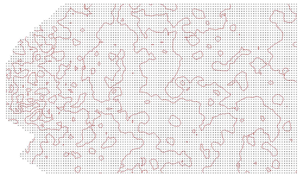
In this case, 38365 points have been used to create 8363 points on the new surface.
To run the tool, first create a new layer for the new surface
Then use points/Point Functions/Filter Points
A dialogue box will appear to allow you to select the source layer,
the layer for the filtered points and the search distance
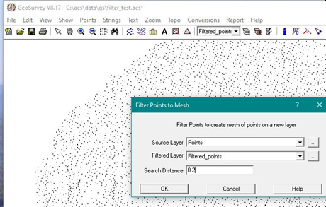
When you hit the OK button, the new layer will be generated with the mesh points.
You can now make the old points layer non contourable and form triangles
and contours using the new mesh pouints.
Source Layer
All points on this layer will be 'filtered' to form the mesh.
Filtered Layer
This should be a new layer and the new mesh points will be inserted on this layer.
Search Distance
This is the distance between the mesh points which will be created.
The height value of the created point will be interpolated using the surrounding 'Source' point heights.
Note
When you read in LIDAR data the file can contain many points which are very close to one another.
Use the "Points Too Close" tool with a reasonable value XY tolerance like 0.02 to clean up the job before contouring.
Once you start, you can choose 'Do All Points' to quickly handle all close points.